Introduction
Foreword
“The Central Kettering Neighbourhood Plan has been written to provide a vision for the future of the town centre and surrounding area, and, in doing so, recognises the importance of this to the people of Kettering, now and in the future.
It lays out a framework that focuses on areas that are of importance to local people, enhancing the Town Centre to provide a safe place with improved amenities, allowing us to have an attractive town centre that is enjoyable to be in, and a great place to shop, eat, and enjoy our time as a community.
It seeks to preserve its heritage by protecting our historical buildings and lays out how brown field sites can be developed for the benefit of the town. In developing the plan, sustainability, preservation and improvement of green spaces has been a priority as well as developing energy efficient buildings and putting in infrastructure that will enable people to travel into town without relying on the car. The plan looks to achieve a housing balance that includes restrictions on HMOs whilst enhancing good housing opportunities for all.”
Kettering Neighbourhood Plan Advisory Panel. (December 2025)
1. Introduction
- Kettering Town Council (KTC) is preparing the first Central Kettering Neighbourhood Plan (KNP) to cover the period from 2024 – 2045. KTC is defined as a ‘qualifying body’ for this purpose in line with the Neighbourhood Planning (General) Regulations 2012 (as amended).
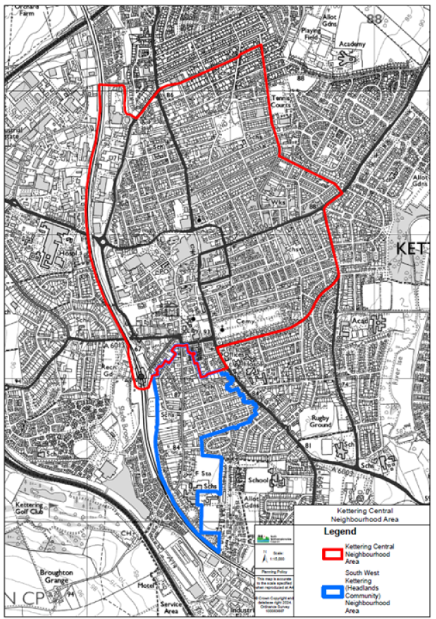
- The Central Kettering Neighbourhood Area was designated by North Northamptonshire Council on the 24th October 2024 as the area to which the policies of the KNP will apply. A map showing the Neighbourhood Area is shown below. The area does not coincide with the Parish Boundary.
- Kettering has a population of 63,150, with around 18,000 people residing within the Central Kettering Neighbourhood Area (as at Census 2021). There is a made neighbourhood plan within the wider Parish; the South West Kettering (Headlands Community) Plan, made in June 2023.
- The KNP will cover the period from 2024 to 2045. This version contains draft policies for determining planning applications for the use and development of land within Central Kettering during that period. In doing so it operates alongside other policies of the NNC development plan that relate to Central Kettering.
2. Background
History
- Kettering is in a central geographical position in England, situated on the old A6 road from London to Carlisle and midway between the M1 Motorway at Northampton and the A1 at Huntingdon, a position now further enhanced by the A14 linking the M6 motorway with the east of England.
- The town lies at the heart of Northamptonshire – an under-rated county, known traditionally as the “county of squires and spires”, of pleasing countryside and stone-built villages and small market towns, a county marked by its great estates and country houses, such as locally Rockingham Castle and Boughton House.T he Town is still dominated by the spire of the parish church and the important Heritage Quarter.
- The landscape is gently undulating reflecting the south west – north east grain of the geology. With the higher ground to the north west of the country of Middle Lias ironstone, then the clayey limestones south east of this – and the Lias, the Northamptonshire sand and ironstone group with other sandy rocks, but importantly south of Kettering is the band of Lincolnshire limestone that stretches through the county and up to the Humber – the most famous of all English freestones, and with its variants known under different names including Ketton and Collyweston slate.
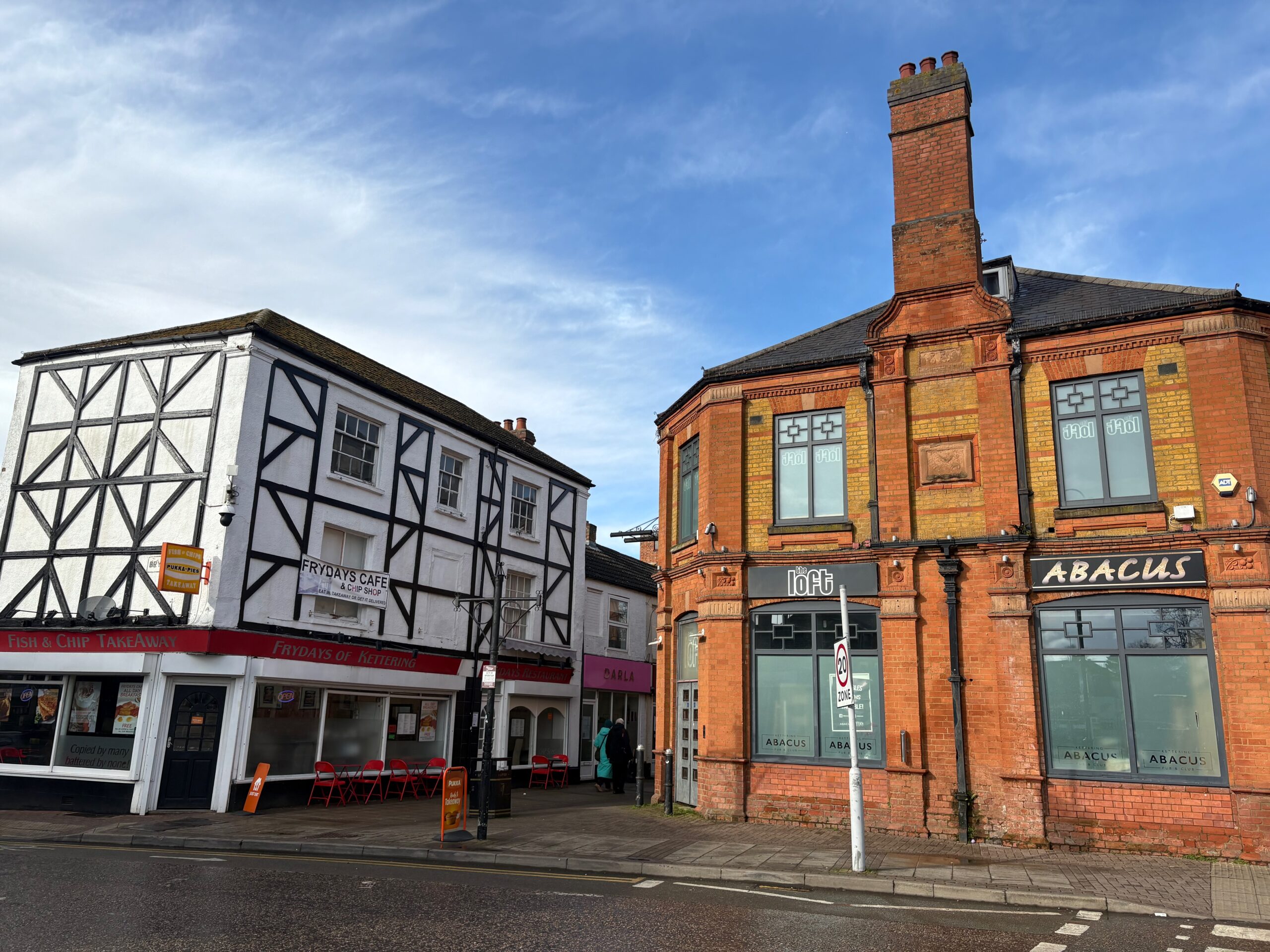
- Kettering’s past has been marked by transition from a rural market Town into a busy modern commercial and Manufacturing centre – which with Northampton and Wellingborough once formed the heart of the shoe making area of Northamptonshire. The passing of the ironstone industry and a large part of the shoemaking industry has resulted in the loss of many of the town’s distinctive factories as well as some of the economic basis for the working population. the redevelopment of major parts of the Town centre (to the north and north west) in the 1970s/80s has locally eroded some of its distinctive character. But apart from this area Kettering still retains an enviable and distinctive architectural cohesion with an urban fabric noticeably more intact than other similar or larger towns.
Profile
- Central Kettering is home to around 18,000 residents across 8,100 households, making it a relatively densely settled urban area within the wider Kettering locality.
- As a well-located settlement along the Oxford Cambridge Arc, Kettering is a focus for residential and employment growth, seen through the allocation of strategic sites such as Hanwood Park and Kettering Energy Park
- Central Kettering has a notably high proportion of single-person households (38.0% vs 30.1% nationally.) This suggests a more urban, perhaps younger or more transient population, and housing stock that caters to smaller households. Two-person households are slightly less common than average, and larger households (4+ people) are also somewhat under-represented (16.9% vs 19.9%), reinforcing the pattern of smaller household units.
- Car ownership in Central Kettering is significantly lower than the England average (30.9% of households have no car or van, compared with 23.5% nationally.) Households with 2 or more vehicles are meaningfully fewer (24.4% combined for 2+ vehicles vs 35.2% nationally).This reflects characteristics typical of town-centre living with greater walkability and access to public transport, and differing income or lifestyle patterns.
- Central Kettering has a high share of 1- and 2-bedroom homes with larger homes less common.
- 1 bedroom: 18.5% vs 11.6% nationally
- 2 bedrooms: 34.7% vs 27.3% nationally
- 4+ bedrooms: 10.9% vs 21.1% nationally
- Property tenure is significantly different to the national average with much lower owner-occupation and higher private renting. This indicates a highly mobile or younger population base, greater demand for rental accommodation near the town centre, and a considerably smaller owner-occupier sector than the national average.
- Owns outright: 20.5% vs 32.5% nationally
- Owns with mortgage/shared ownership: 24.3% vs 29.8% nationally
- Private rented / rent free: 39.6% vs 20.6% nationally
- Residents of Central Kettering tend to work closer to home than the national average with 46.5% travelling less than 10 km, compared with 35.4% nationally. Working from home is much less common with only16.3% vs 31.5% nationally. This is a major deviation, suggesting either fewer office-based remote-work roles, a more service-oriented urban employment market, or housing constraints that make working from home less practical.
- In terms of modes of travel to work, walking is much more prevalent (17.9% vs 7.6% nationally) Car sharing is greater (8.5% vs 3.9% nationally) with driving slightly higher than average (48.4% vs 44.5% nationally). Few residents use the train despite good rail connections to London although it was felt this figure was very likely to be higher in other residential areas of Kettering rather than the Town Centre.
- In respect of economic activity Central Kettering shows higher employment rates among those aged 16+: (63.7% vs 57.4% nationally.) Unemployment levels are equal to the national average at 3.5%. This suggests a comparatively engaged labour force with fewer retirees, students, or long-term inactive individuals.
Strategic Planning Policy
- Whilst no longer a requirement under Basic Conditions, the KNP has been prepared to be in general conformity with the strategic policies of the North Northamptonshire Development plan for the area, comprised of the Joint Core Strategy 2011-2031(JCS) (Adopted 2016) and the Kettering Site Specific Part 2 Local Plan 2011 – 2031 (SSP2) (2021). The Local Plan and Core Strategy policies will be replaced by an updated Local Plan, which will be prepared under the new 30 month local plan making system, with adoption expected early in 2029.
- The key Local Plan policies affecting Kettering are:
Joint Core Strategy 2011-2031(JCS) (Adopted 2016)
- Policy 1 – Presumption in Favour of Sustainable Development
- Policy 2 – Historic Environment: protect and enhance heritage assets, Conservation Areas, and locally significant buildings.
- Policy 4 – Biodiversity and Geodiversity: requires net gains and habitat connectivity.
- Policy 6 – Development on Brownfield Land.
- Policy 8 – North Northamptonshire Place-Shaping Principles: Requires development to respond to local character, reinforce distinctive places, ensure quality design, and improve the public realm.
- Policy 9 – Sustainable Buildings: requires high environmental standards, orientation, and adaptability
- Policy 11 – Network of Urban and Rural Areas: identifies Kettering as a Growth Town and the principal focus for employment, retail, leisure, housing and service provision.
- Policy 12 – Town Centres and Town Centre Uses: requires maintaining Kettering’s role as the largest retail centre in North Northamptonshire.
- Policy 15 – Well-Connected Towns, Villages and Neighbourhoods: prioritises walking, cycling and public transport.
- Policy 19 – Green Infrastructure: integrates with biodiversity and active travel corridors; encourages multifunctional green routes for movement and biodiversity.
- Policy 22 – Delivering Economic Prosperity: supports redevelopment of vacant premises and diversification of the economy.
It states: Kettering will be the largest retail centre and its vibrant town centre, regarded for being characterful, distinctive and fun, will provide a focus for its surrounding market towns and villages. The town will be the focus for healthcare and will lead the way in renewable energy investment to strengthen the green economy. Its business community will capitalise on its excellent connectivity, including its position on the Trans-European (E24 route) A14 and on the electrified Midland Mainline rail route.
Kettering Site Specific Part 2 Local Plan 2011 – 2031 (SSP2) (2021)
- NEH2 – Borough Level Green Infrastructure Network (BLGIN). Sets expectations to integrate with the borough GI corridors and prepare site-specific GI strategies for qualifying schemes—supports KNP movement/green links.
- NEH3 – Historically and Visually Important Local Green Space (LGS). Designates LGS and sets the protective policy test (very special circumstances)
- HWC1 – Health and Well-being. Supports provision of health facilities and encourages active/healthier lifestyles;
Kettering Town Centre Area Action Plan 2011 – 2021 (KTCAAP) (2011)
- Policy 1 – Regeneration Priorities (programme focus, key sites & delivery).
- Policy 2 – Urban Quarters, Urban Codes & Development Principles
- Policy 3 – Primary Shopping Area; Primary & Secondary Frontages; Evening Economy
- Policy 6 – Residential (supports new housing in the centre subject to amenity/quality).
- Policy 8 – Parking
- Policy 9 – Public Transport & Policy 10 – Pedestrian & Cycle Network (priority for bus, walking, cycling; links between quarters).
- Policy 11 – Public Realm & Public Art
- Policy 12 – Heritage, Conservation & Archaeology
- Policy 13 – Open Space, Green Infrastructure & Biodiversity
- Policy 18 – Restaurant Quarters
- Policy 20 Silver Street Quarter
- Policy 22 Cultural Quarter – civic/cultural focus around the Gallery/Library/Manor House; green setting.
- A Local Transport Plan (LTP) is being prepared to update the previous version in 2012. The baseline documents positions Kettering as the principal sustainable-transport hub in North Northamptonshire and seeking to address the following:
- Deliver LCWIP priorities including— segregated cycle links, junction upgrades, pedestrian crossings. Upgrade the Station Quarter interchange — improve walking and cycling approaches, secure cycle parking, wayfinding and bus connections.
- Expanding the EV charging network — build on the existing 18 sites and trial a rapid or hub-type facility in/near the town centre.
- Casualty reduction — traffic-calming and safer crossing points on main desire lines to the centre, schools and employment areas.
- Embedding climate resilience — apply SuDS by default in all highway and public-realm projects, adding trees and sustainable materials wherever possible.
National Planning Policy
- The KNP has also has regard for national planning policy and guidance as set out in the National Planning Policy Framework (NPPF). The Basic Conditions Statement contains further details on how the Plan accords with the current NPPF but the key policies are:
- §30 – neighbourhood planning gives communities the power to develop a shared vision for their area, which can shape, direct and help to deliver sustainable development, by influencing local planning decisions
- §74- giving consideration to allocating small and medium sized sites suitable for housing in the area.
- §83 – promoting sustainable development in rural areas.
- §98a – planning should provide the social, recreational and cultural facilities and services the community needs, planning policies and decisions such as local shops, meeting places, sports venues, open space, cultural buildings, public houses and places of worship)
- §98c/d – planning should also guard against the unnecessary loss of valued facilities and services, particularly where this would reduce the community’s ability to meet its day-to-day needs and should ensure that established shops, facilities and services are able to develop and modernise, and are retained for the benefit of the community
- §105 – protect and enhance public rights of way, including taking opportunities to provide better facilities by adding links to existing rights of way networks.
- §106 – Local Green Space designations
- §109e- identifying and pursuing opportunities to promote walking, cycling and public transport use.
- §216 – Non designated Heritage Assets.
It is noted that the draft 2026 NPPF has recently concluded consultation. As such, the Basic Conditions Statement will also demonstrate consistency with the emerging plan and the National Decision Making Policies contained within, to ensure the Neighbourhood Plan has functional weight post adoption.
- The KNP must demonstrate how its policies contribute to the achievement of sustainable development and how they will not cause any harm to important ecological areas (in respect of the Habitats Regulations). The Neighbourhood Plan has been screened out for the need for a Strategic Environmental Assessment and Habitats Regulation Assessment. Environmental matters are also addressed in the Basic Conditions Statement.
Project Progress
| Date | Project Stage |
|---|---|
| 15th February 2024 | Neighbourhood Planning Committee agreed a scoping document for the coverage, geography and objectives of a new neighbourhood plan |
| 12th June 2024 | Workshop with Councillors, facilitated by external advisors, about purpose, scope and geography of the plan, to inform Council |
| 10th July 2024 | Council agrees scope of plan and geography, and to ask NNC to designate the plan area and to seek tenders for planning consultancy support. |
| 24th October 2024 | Area of the plan designated by North Northamptonshire Council |
| 30th October 2024 | Tenders from consultants received and considered by committee who identified a preferred bidder and invited them to their next meeting on 20th November 2024 |
| 20th November 2024 | Constitution and membership of the Advisory Panel (comprising Councillors and community members) agreed by committee |
| 11th December 2024 | Council appoints ONH as planning consultants to project manage and help develop the plan. |
| 30th January 2025 | Project plan agreed by committee. |
| 19th February 2025 | Advisory Panel has first meeting and continues to meet monthly throughout 2025 to work on plan policies and evidence gathering. (10 meetings including 2 held jointly with the NP Committee |
| 26th February 2025 | Town Meeting took place with 50+ attendees, to start first stage engagement, in workshop format to consider scope and direction of plan. |
| 6th March 2025 | Similar session with Tresham students (50+ attendees) to progress engagement, supplemented by a session Tresham convened themselves with some adult learners. |
| February-March 2025 | Online public survey running |
| 14th June 2025 | Engagement with 90+ attendees at Kettfest on principles of plan and local issues to be addressed. |
| 23rd July 2025 | First draft of policy outline submitted to and agreed by committee. Revision to timetable to reflect withdrawal of government grant and need to stretch resources into following financial year. |
| 29th August 2025 | Screening Opinion for SEA and HRA submitted to NNC and then on to statutory consultees. |
| End September 2025 | Owners of buildings and land specifically mentioned in the plan written to by Town Council, seeking views on proposed designations (Key buildings, Local Green Spaces and Local Heritage Assets). |
| 1st October 2025 | Second Town Meeting (55 attendees) to consider policy areas and detail of policies in workshop format |
| To end October | Second online survey |
| 13th October 2025 | Screening opinion decision by NNC not to require an SEA or HRA |
| 16th December 2025 | NP Committee considers final draft pre-submission document for onward recommendation to Full Council in January 2026 |
| January 2026 | Full Council approval to proceed to Regulation 14 |
| 2nd February – 23rd March 2026 | Regulation 14 consultation |
| 2nd April 2026 | Advisory Panel reviews Regulation 14 responses and agrees changes to NP |
| 15th April 2026 | NP tabled for approval by Neighbourhood Plan Committee prior to ratification by Full Council in May |